One of the most comprehensive aerial surveys of methane gushing from US oil and gas facilities shows operators must slash emissions by roughly 80% or more to meet major industry targets.
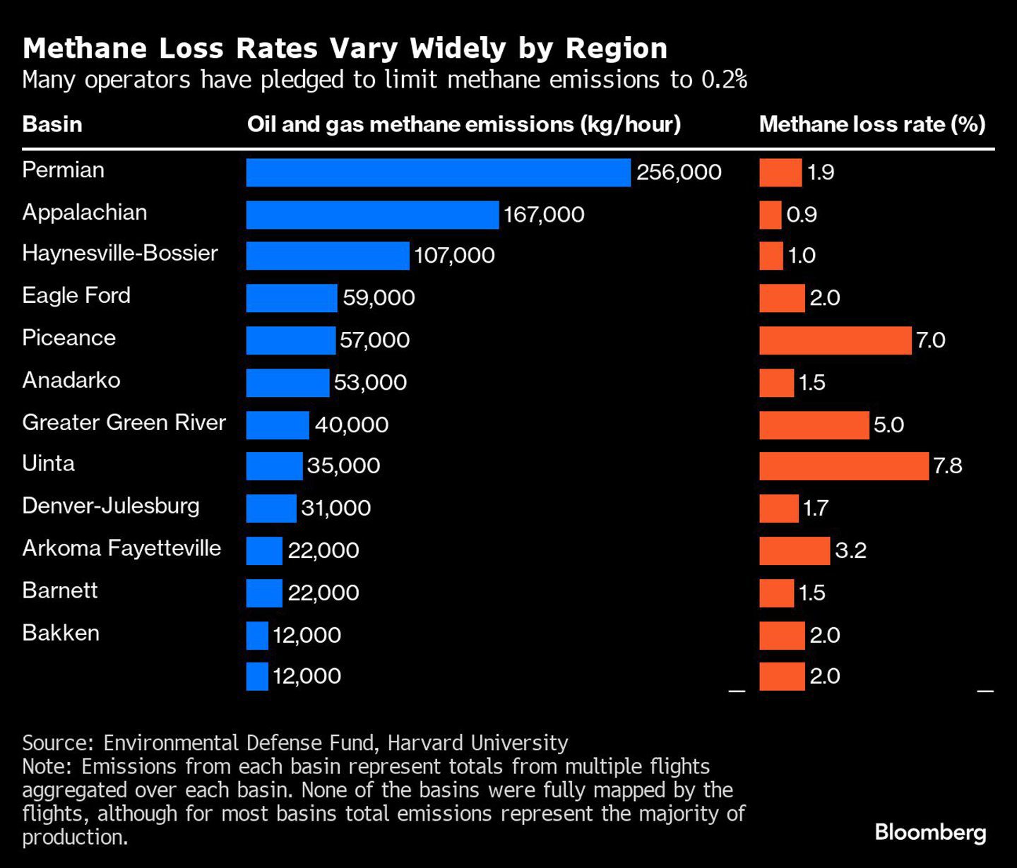
The nonprofit Environmental Defense Fund conducted about 30 flights between June and October of last year over fossil fuel basins that account for nearly three-quarters of onshore oil and gas production in the contiguous US. On average, the data collected show that around 1.6% of gross gas production is released as methane into the atmosphere. That’s about eight times higher than what many operators have pledged to reach by 2030 or earlier in a bid to limit their emissions under programs including the Oil and Gas Climate Initiative and the Oil & Gas Decarbonization Charter.
The empirical observations come as new US Environmental Protection Agency methane rules set requirements for monitoring, repairing and replacing equipment at storage tanks, compressors, pneumatic pumps and other equipment used at oil and gas wells. The agency’s Super Emitter Program plans to leverage advanced detection technologies including satellites, aerial surveys and mobile monitoring to help identify and halt methane emissions.
A spokesperson for the American Petroleum Institute said oil and gas producers welcome transparency and accountability when it comes to emissions. “Our industry is working every day to meet growing energy demand while making significant progress in reducing methane emissions, and we can build on this progress through a sound EPA reporting framework, effective federal regulations and the deployment of advanced detection technologies,” American Petroleum Institute Vice President of Upstream Policy Holly Hopkins said in a statement.
The findings from EDF also have implications for liquified natural gas exports. The US is the largest exporter, and the data suggests the emissions could impact shipments to regions like the European Union, which will soon require buyers to pay a price for pollution embedded in imports.
The data was captured by an imaging spectrometer mounted on a Lear 35 aircraft that can observe methane concentrations by analyzing the way sunlight reflects off the Earth. As light passes through a cloud of the gas, its intensity is weakened on certain wavelengths. The equipment is a precursor to more powerful and comprehensive observations from EDF’s MethaneSAT satellite that blasted into space in March and is scheduled to start releasing data as soon as this year.
The EDF survey covered portions of a dozen major fossil fuel production regions including the Permian, Appalachian and Anadarko basins. Basin loss rates varied widely between 0.94% and 7.8%. The total derived emissions rate of 860 metric tons of methane an hour across the 12 basins included in the analysis is more than four times the corresponding EPA gridded inventory as of 2020, the most recent data available.
 © Supplied by Bloomberg