Hugely humbling and poignant.
That’s how engineer Chris Harvey described his subsea 3D scanning firm’s role in shedding light on the final moments of a US submarine destroyed in the Second World War off Alaska.
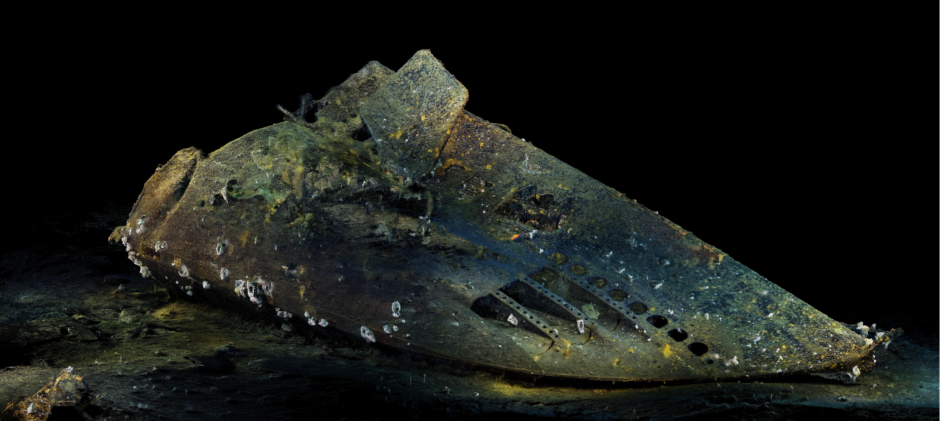
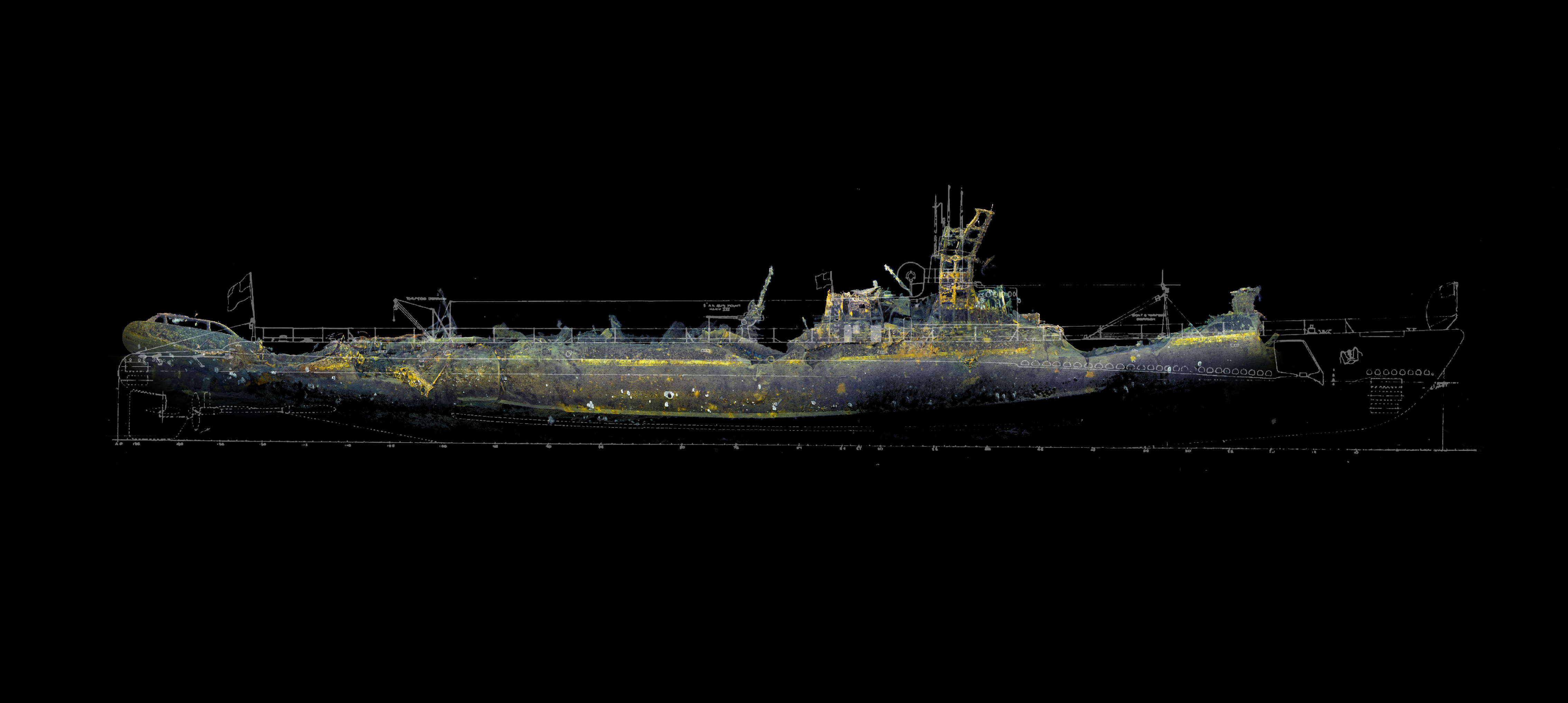
Viewport3 turned more than a day’s worth of video footage of the USS Grunion into incredibly detailed 3D images that can be conveniently studied by researchers, archaeologists and history buffs like Mr Harvey.
It took more than four months and a staggering 5.3 trillion pixels to construct the visuals, which even show barnacles, crabs, fish, and individual rivets on the submarine, such is the level of clarity.
Mr Harvey could only ever dream he would be involved in a project like
this one.
He and co-director Richard Drennan set up the firm primarily to work on inspection projects with clients in the oil and gas, subsea and marine sectors.
Viewport3 is still being kept busy by that sort of break-and-butter work.
At the same time, they knew their photogrammetry technology was versatile enough to be applied to a range of tasks.
Last summer, they visited the old P&J digs on Lang Stracht to give EV a taste of what their technology could do by scanning a scrapbook of old newspaper clippings and creating 3D electronic models.
It was impressive then, but a 90-metre-long submarine, smashed into two pieces and lying at depths of almost 1,000 metres is a different ball game.
Viewport3 got involved after catching the eye of renowned US explorer Tim Taylor with its 3D renderings of an unexploded bomb off Whitby.
He thought the Dyce-based company could bring something new to his ambitious mission to document and account for the locations of the 52 American submarines lost in the Second World War.

The subsea footage of USS Grunion shot by Mr Taylor’s team using remotely-operated vehicles (ROVs) is relatively clear, but only because the mounted cameras were so close to the wreck.
Any further away and the murkiness of the water would have rendered the footage useless for the purposes of Mr Taylor, chief executive of Tiburon Subsea Services, an underwater technology rental firm based in New York.
As such, individual frames only captured a few square metres of the exterior of the submarine.
At times, it’s unclear which part of the vessel is being shown.
The 3D models generated by Viewport3 show the entire bow and stern of USS Grunion and allow users to zoom in and out, and swivel and rotate the images as they please.
It’s far more convenient for researchers, who would otherwise have to sift through 25 hours’ worth of video footage to find the section they wish to inspect.
The quality wouldn’t be as good, either.
Mr Taylor was suitably impressed with the results, hailing Viewport3’s images as “truly the future of underwater archaeology”.
He added: “We hope this latest data – with its unprecedented accuracy – will help us to explain what happened to the USS Grunion, as well as honour the entombed sailors.”
Mr Harvey said the project was “incredibly exciting” to work on, but also hugely humbling, as the USS Grunion is the “final resting place for 70 sailors” lost in 1942 off the island of Kiska.
Having sunk two Japanese patrol boats, the submarine was ordered back to base in July that year, but it was never heard from again. It was later assumed “lost with all hands”.
The stern was discovered about 12 years ago with help from the family of the submarine’s captain – Mannert L Abele. The missing bow section was located by the team working on the Lost 52 Project just last year.
Led by Mr Taylor, the team has discovered and mapped four out of eight submarines located to date.
The most likely theory explaining what happened to USS Grunion involves an encounter with a Japanese ship.
There is so much to discover about the vessel, some of it highly poignant.
The main products of Viewport3’s work are the 3D models of the bow and stern. Mr Harvey said those models have a higher level of detail than the original drawings for the submarine, which are held in the US National Archives.
But the company has also provided fly-through video clips and, using scan sonar laid on by Mr Taylor, an image of the position of the bow and stern.
The stern is about a quarter of a mile further down the bank of an underwater mountain than the bow.
Amazingly, the image still shows the slide trail made by the stern, which was undisturbed for 70 years.
The value of the models could become even more pronounced the next time someone explores the wreck site.
A large earthquake struck the area last year, after Mr Taylor’s footage had been shot.
The bow and stern could have moved, as a result. If so, they’d almost certainly have suffered further damage, breaking into smaller pieces.
The slide trail could be wiped out, too.
Mr Harvey hopes to keep working with Mr Taylor, remarking: “He has big plans and so do we.”
As much as he enjoyed the USS Grunion project, Mr Harvey acknowledged that Viewport3 didn’t do it for free.
Asked how much money the project generated, he said the contract value was “undisclosed”, but “reflected the effort the team put in.”

